Mozambique’s Floods: When Weeks of Rain Overwhelm the Land
By late January 2026, parts of southern Mozambique had experienced weeks of persistent rain through December and January. Rivers swelled and reservoirs were overwhelmed, while satellite images showed the Limpopo and Incomati…
By late January 2026, parts of southern Mozambique had experienced weeks of persistent rain through December and January. Rivers swelled and reservoirs were overwhelmed, while satellite images showed the Limpopo and Incomati spreading across broad plains that had surrounded their narrower channels only weeks earlier.[1]
As the water spread, communities lost access to their homes and familiar places. UNICEF reported that more than 723,000 people were affected between 9 January and 1 February, using figures from national authorities.[2] The emergency depended on more than the rain over a particular town, since water accumulating across the land continued moving through connected rivers even after local weather improved.
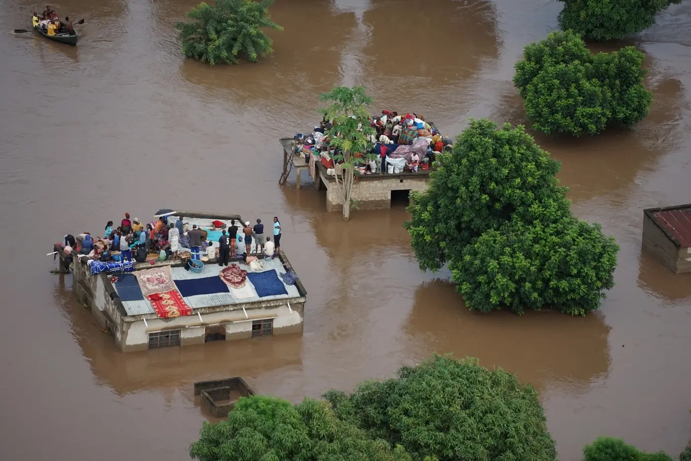 Residents shelter on rooftops in a photograph published during Mozambique’s 2026 flood response.
Credit: © Mercy Air / FAO.
Residents shelter on rooftops in a photograph published during Mozambique’s 2026 flood response.
Credit: © Mercy Air / FAO.
When Mozambique’s Rain Became Floodwater
Soil can absorb some rainfall when it has space to store water, reducing how much immediately enters nearby streams. Repeated rain gradually fills that storage. As the ground becomes wetter, a greater share of the next rainfall can flow over the surface as runoff and reach waterways.[3]
The length of a wet period matters because each new downpour arrives on land already affected by earlier rain. Streams may be high and the soil may have little storage left. If the volume reaching a river becomes greater than its channel can carry, water spreads onto the surrounding floodplain.
During Mozambique’s January emergency, CIMA Research Foundation described completely saturated soils and catchments with very high river levels. Its monitoring warned that even a relatively brief burst of further rain could worsen flooding.[4] The preceding weeks had left the land less able to take in additional water.
Water Arriving From Upstream
A river receives water from its drainage area, or catchment, where smaller streams join larger ones. Rain falling in one part of this area can contribute to flooding somewhere else.[5] The Limpopo basin extends across Botswana, South Africa, Zimbabwe and Mozambique, connecting upstream conditions with the flood risk farther downstream.[6]
During the emergency, rainfall in neighbouring countries added to rising rivers in Mozambique, while reservoir releases contributed additional flow downstream. Those inputs could prolong flooding even as local weather improved. On 22 January, CIMA reported that southern Mozambique had experienced no new rain for 48 hours, yet water levels were still rising in downstream stretches of the Limpopo.[4]
A dry afternoon may therefore give residents little indication of the water still approaching. Warnings need to consider rainfall and river levels across the catchment as well as the local forecast, so that an improvement overhead is not mistaken for an end to the danger.
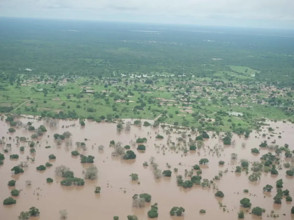 Flooding in Gaza Province, photographed during a survey on 18 January 2026.
Credit: Mercy Air – Mozambique Flood Survey / CIMA Research Foundation.
Flooding in Gaza Province, photographed during a survey on 18 January 2026.
Credit: Mercy Air – Mozambique Flood Survey / CIMA Research Foundation.
The Climate Behind the Rain
The weather producing those downpours had several influences. World Weather Attribution’s rapid analysis examined rainfall accumulated over ten days across the affected region. It found that the season’s weak La Niña, a recurring climate pattern, increased the likelihood and intensity of the heavy rain.[7]
The researchers also concluded that human-caused warming had made such rainfall more likely and more intense, using observations, physical understanding and earlier research. However, climate models struggled to reproduce the region’s relationship with La Niña, preventing them from confidently quantifying the contribution from warming.
There is evidence that warming worsened the rainfall hazard, but uncertainty remains about the size of that effect. The analysis does not attribute a percentage of Mozambique’s damage to climate change, since the damage also depends on where the water flows and what it reaches.
A Harvest Lost Under Water
For farming households, the timing of that journey made the losses particularly serious. The floods arrived after crops had been planted and before harvests expected in March and April. In its February assessment, the Food and Agriculture Organization reported roughly 275,000 hectares of destroyed cropland, with fields washed away, covered in sand and debris, or left waterlogged and inaccessible.[8]
A lost crop removes both food and potential income. If seeds and tools are also lost, families may struggle to begin planting again. Losing livestock adds to the difficulty because animals can supply food and farm labour, as well as assets that households use to meet expenses.
Returning to a field after the water recedes does not mean a family has what it needs to restart production. FAO’s proposed response combined seeds and tools with support for surviving livestock, accounting for several losses at once. The timing of assistance also matters because families need to receive it while another crop can still be planted within the agricultural calendar.
Health Risks Beyond the Flood
Temporary accommodation can increase health risks when many displaced people share inadequate water and sanitation. WHO identified the risk of diarrhoeal disease during the emergency, along with interruptions to maternal care, vaccination and treatment for chronic illnesses.[9]
Even after reaching safety from floodwater, a household may be unable to get to a clinic or continue essential treatment. Restoring these services remains necessary after the initial rescue effort.
By late February, WHO was reporting a sharp regional increase in cholera, with Mozambique accounting for most reported cases in southern Africa. Its assessment identified several interacting pressures, including flooding, displacement and inadequate water infrastructure.[10] That broader context matters: the figures describe an overlapping public health crisis and cannot all be attributed to this single flood episode.
Warnings That Reach Communities
The movement of water downstream can leave time to prepare if communities receive useful warnings early enough. With WMO support, Mozambique has been strengthening rainfall and river monitoring, forecasting and warning services. This includes improving communication and involving communities so the information can guide action.[11]
An alert needs to help people decide when to leave and identify somewhere they can reach safely. Some residents will also need transport or assistance, which requires arrangements before evacuation begins. Forecasts are more useful when these practical needs are considered alongside the information.
The attribution assessment also called for coordination across river basins, improved local infrastructure and community preparedness.[7] For families beside the Limpopo, these changes could provide enough notice and support to leave while the route to safety is still accessible.
Sources
- Floods Inundate Southern Mozambique
- Seeking safety after floodwaters caused destruction the district of Chókwè
- Water Q&A: Floods
- Mozambique, heavy rainfall in the South: cooperation and monitoring to manage flood risk
- Watersheds and Drainage Basins
- LIMCOM @20
- La Niña, Climate change, high exposure and vulnerability combined led to devastating floods in parts of Southern Africa
- Mozambique Floods
- Around 1.3 million people affected by severe flooding in Southern Africa
- Southern Africa faces acute surge in cholera due to floods, displacement
- Strengthening Mozambique’s Early Warning Systems through Meteorological and Hydrological Capacity Building